GIS ObjectLand 2.7.7
GIS ObjectLand is a universal Geographic Information System for Windows
GIS ObjectLand is a universal Geographic Information System for Windows. Key features: using spatial data and tables from internal or external DBMS; multiuser data editing; import/export for MIF/MID, SHP, DXF, DBF, CSV; access permissions for users.
Software Specs
Publisher:............ Radom-T
License:............... Shareware
Price:................... $199
File size:.............. 28.15 MB
Downloads:.........
Release date:...... 09 Jul 2012
Last update:........ 07 Dec 2013
Language:............ English
Publisher review for GIS ObjectLand 2.7.7:
Review by: Radom-T
GIS ObjectLand is a universal Geographic Information System for Windows.
Key features:
- creation of vector-raster maps with arbitrary structure of layers and feature types in an internal ObjectLand database or in following DBMSs - MS SQL Server, Oracle, DB2, MySQL, Interbase/Firebird, PostgreSQL, MS Access;
- creation of themes. Theme is a user presentation of a map;
- control of displaying features depending on the chosen scale;
- spatial data input and editing by assigning feature coordinates and also by interactive drawing with mouse or digitizer;
- sewing of separate pages of an imported map into one unified continuous map;
- copying, merging, and moving maps, layers, and feature types between different geoinformation databases;
- creation of tables of arbitrary structure;
- creation of queries. Query is a user presentation of table built by setting search and sorting conditions, joining tables, calculations and using reference tables;
- copying, merging, and moving tables and queries between different geoinformation databases;
- setting arbitrary links between spatial and table information;
- getting information about the feature selected on the map;
- searching for features on the map by linked records;
- creation of filters. Filter is conditions of feature visualization depending on spatial properties of features and linked table data;
- creation of layouts. Layout is an output form combining spatial, table information and presentation elements;
- import and export of table and spatial information for widespread data formats;
- support of style libraries containing fonts, map symbols, line styles, hatches and fill styles;
- style editors for displaying styles;
- setting for users the access permissions to components;
- multiuser data editing;
- using and editing tables of external database (via ODBC) as linked tables;
- providing automation COM interfaces for user applications.
Requirements:
Standard PC
Operating system:
Win95,Win98,WinME,WinXP,WinNT 4.x,Windows2000,Windows2003
Limitations:
Noncommercial version
Release notes:
New Release

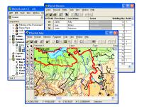
GIS ObjectLand screenshots:
GIS ObjectLand download tags:
ObjectLand GIS geographic information system geoinformation system MIF MID SHP DXF DBF CSV cadaster cadastre cartography topography geodesy geomatics GIS technology GDB geoinformation data base map table theme view layout query la
Copyright information:
Based on 0 ratings. 0 user reviews.
DBDesigner 4
DB-MAIN
SQL-Front
Full Convert Enterprise
PC-Telephone
Liquid Desktop
Advanced Access Repair
Oraspeed SQL Editor
ERD Concepts
Accounting and Finance
Office Suites and Tools
Inventory and Barcoding
PIMS and Calendars
Databases and Tools
Project Management
Helpdesk and Remote PC
Calculators and Converters
Vertical Market Apps
Investment Tools
Math and Scientific Tools
Other
Timesheets MTS Software
Softvoile
NewFreeDownloads
Office Suites
PIMS
Math
Calculators
Helpdesk
Databases
Accounting
Inventory